Monday, April 30, 2012

Robe

Robe is a pretty seaside town with old world charms and with a population of about 1200 people during the off season. Many of the older buildings along it's one main street are of stone construction and with most having verandahs. Away from the CBD area there are many new and modern homes. Some of these homes seem to be holiday homes, maybe owned by people from Adelaide as many seem vacant.

They think they are something special here at Robe, our un-powered site here is $32 per night. The site here looks spacious but we are really spread over two sites.

The 'Obelisk' here is a sighting beacon and is lined up with other points further inland to gain safe entry to the port. I can't tell you much about it because the information board is grossly faded by sun and probably salt spray from the waves crashing below. The Obelisk will not be here for perpetuity as it's foundation is being eroded by wave action on the right hand side.

There is an extensive and modern marina at Robe. There are many empty berths at this time of year but come holiday time I would assume that the picture would be very different.

The Robe Hotel is typical of the type of construction employed by most of the buildings in the CBD Precinct.

Opposite the Robe  Hotel is the main beachfront with it's avenue of Norfolk Pines.

Around the point is The Long Beach with the SeaVu Caravan Park perched on the point. This CP is very exposed to the elements, the view might be grand but if the wind was blowing hard it would be very unpleasant indeed.

A general view down the Main Street of Robe from near the Information Centre.

Beachport

Beachport is a very small fishing/holiday village. The population of about 500 during the off season would grow considerably during the holiday season, as with most seaside towns. All the locals seem to be associated with the Lobster fishing or support industries.

The central point of Beachport is it's jetty. Built around the mid 1800's it's completed length was 4000 feet (about 1230 m) with a 200 feet head section. It is currently about 2500 feet long (about 760 m). 

A view from a lofty vantage point looking over a boat yard towards the end of the jetty. Apart from tourism during the peak season the main industry here is Southern Rock Lobster Fishing. We spoke to the owner of the boat that is just coming out of boat shed, all the catch from the SA coast is destined for China, Aussies cannot afford the price.

Jude and I were wandering around the side streets of Beachport and found some interesting sights, like this 'His and Hers' toilets behind a house. They didn't seem to mind me walking in and taking this photograph.

Tucked in between two buildings on the main street is this tiny church. There is no information signage but even though it has been refurbished I would assume that it has been here for some time.

Thursday, April 26, 2012

Penola and Naracoorte

Temporarily leaving Mount Gambier behind we ventured north to Penola, the gateway to the Coonawarra Wine Region of South Australia. The Coonawarra region produces superb red wine grapes, some say the best in the world. This is due to Terra-Rossa soil type and the semi arid cool climate. Gary and Ann Trotter, "prick-relations" of ours have a winery in the region called "The Blok", only 2.5 km north of Penola. We managed to secure o dozen of the most delightful 'Reds' you could imagine. Pity the caravan park experience was a complete let down. This caravan park is not at all representative of the town of Penola or the area at large.

While in the area we ventured north to Naracoorte, a neighbouring town, that is home to an Heritage Listed Underground Cave System. We took a guided tour through the "Victoria Cave", which in fact is only a very small part of the entire cave system. What we did discover though were fossils from ancient animals that had become trapped in the caves during the period 500,000 through to 230,000 years ago. We were also able to partake in a self guided tour of 'The Wet Cave'.

Our plan now is to return to Mount Gambier where we have the caravan booked-in with the Jayco Dealer for some small maintenance procedures.

There are many sink-holes throughout the limestone region of South East South Australia but the sink-holes in this area open into a vast underground cavern.

This is the interior of the "Wet Cave".

Still in the "Wet Cave" the area is large enough that you could easily live down there.

Apparently this is one of the animals that once roamed this area. Now he/she is stationary in the Picnic Area. Needn't fear this one it's only a leaf eater.

This is the Information Centre for the Naracoorte Caves Conservation Park.

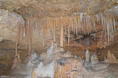
The Guided Tour of 'Victoria Cave' was divided into two distinct zones. The first section was all 'Stalactites' and 'Stalagmites' in vast array of formations. This is just one of the many we were shown.

The second section of the Victoria Cave was much deeper and is the resting place of at least 100 different species of ancient fossilised remains that are complete and in very good condition as you can see by this skeleton of a Marsupial Lion.

Wednesday, April 25, 2012

Mount Gambier

Mount Gambier, the second largest city in the State of South Australia, is a beautiful city and the residents there are friendly and helpful. Of course Mount Gambier is widely known for it's Crater Lake that holds vivid blue water during the months November through March and changing to steel grey over winter. The lake has been the city water supply since 1884,  the water level has only dropped by two metres in that period. There is believed to be at least 70 metres depth remaining.

It is now the month of April and the water in the lake still retains some of the famous blue colour.

The pumping station can be seen in this photograph sitting about 50 metres above the water level.

The path that Judy is standing on follows the rim of the Blue Lake Crater for the entire circumference. The distance is something like 3.8 kilometres, many locals walk or jog this circuit for their daily exercise. The 'Rook" in the background is the beginning of a walk over the crater rim to another crater lake named "Leg of Mutton Lake"

There are many 'sink-holes in the limestone that is the foundation stone of much of the South East of South Australia. This sink-hole is in the centre of the City of Mount Gambier.

'The Main Building', on the corner of Commercial Street East and Bay Road, is the home of The Mount Gambier Art Gallery. The sink-hole shown above is immediately behind this building.

Sink-Holes in the South East of South Australia are quite common. This park contains one of the largest and is also situated within the City area of Mount Gambier.

This is Umpherston Sink-Hole in Mount Gambier. As you can see it is very large indeed. There are ramps and steps that provide pedestrian access to the bottom of the sink-hole.

Friday, April 20, 2012

Port Macdonnell

We decided to make a day tour from Nelson to Port Macdonnell as this was not on our planned route. Along the way there was a turn-off to Piccaninnie Ponds Conservation Park and we decided that this was worth investigation.

 
Piccaninnie Ponds Conservation Park is on the coast of South Eastern South Australia. This is the view from atop the sand dunes along the coast towards Port Macdonnell.

The main pond of The Piccaninnie Ponds system. These ponds are very popular with snorkelers and scuba divers. This pond is 75 metres deep and cone shaped. There is another cavern beneath this pond that is accessible through a narrow opening.

The clarity of the water in Piccaninnie Ponds is astounding.

The wharf at Port Macdonnell, with moored fishing vessels visible in the back ground.

The day of our visit there was a stiff south-westerly blowing. Great conditions for these kite flying enthusiasts.

Some of the vessels moored in the harbour. This photograph taken from the end of the wharf.

At Port Macdonnell there is a huge breakwater. The semi circular wall must be close to 1000 metres in length. The last half of the wall is visible in this photograph.

The larger 'Cray Boats' are removed from the water in the off season and stored in this holding area.

More 'Cray Boats' from another angle. Many of these boats are 43 feet (approx 13 Metres) in length.

Nelson

We arrived at Nelson and we had a robust discussion as to how long to book into the caravan park. The end decision was to stay for a week, this was too long as it turned out, and as Judy continued to remind me. Activities in Nelson revolve around the Glenelg River and water activities. Along with some points of natural significance, such as Princess Margaret Rose Caves.

There is not a lot to the town of Nelson, the picturesque river lined with many 'boat houses' is the main focus. From the highway through the town, this is the view across some park land towards the Glenelg River.

The total focus of Nelson is on the Glenelg River. Here is a River Cruise boat, notice how it is all enclosed, the weather here must become very inclement most of the time.

Nelson is not a large town, there are not many business here, the Nelson Hotel is one of three retail businesses, the river Kiosk just to the right of this photograph is another and the BP Servo on the Main Road is the other.

We drove along a bush track through Lower Glenelg National Park and followed the course of the Glenelg River along the southern bank. There are also many access points on the north side of the river but one would have to drive many kilometres to get there from Nelson.

At several places along the river canoe/boating landing places are constructed. Some are accessible from the river only others are also accessible by road. Such as this point named 'Sapling Creek'.

This photograph is at 'Battersbys'. Along with the access point to the river there is a fairly large camp area here. The day we were visiting, a group of walkers from the GSWW (Great South-West Walk of 250 km over 10 days) were going to use this camp area as an over night way point.

Still at 'Battersbys', the guy on the left was a member of a group driving and seeking out all the river access points, as we were. The guy on the right, Gordon, transports all the gear and was setting up the camp area for the participants of the GSWW.

Our final view of the river today was at 'Pritchards'. This area has a boat ramp and is accessible by large caravans. There were 10 sites at the low level and about 10 sites at the upper level. Not all sites are large enough for caravans and permits are required before arriving. In high usage times permits are allocated by ballot.

This phenomenon is known as 'The Inkpot'. It is formed by the land surface collapsing into a 'sink-hole' created by the dissolving of the limestone below by the passage of ground water. The water is black as ebony due to the rotting of fallen vegetation.

Wednesday, April 11, 2012

Tyrendarra and The Fitzroy River

During our four day stay at Saw Pit Reserve we met up with Ashley and Diane, fellow Queensland travellers from Airlie Beach. They returned to camp one day and said that they had found a better place to camp and were going to move right away. We told them to expect a visit from us the following morning. After making a quick "reccy" we soon went back and collected our caravan and moved camp. We were at the Outlet of The Fitzroy River where it meets the Southern Ocean. We were there with about 200 other campers over Easter. Steve and Kay from Brisbane joined us and the trio of Queenslanders had a great Easter together. The first "Happy Hour" together continued for six hours!

Our trio of couples from Queensland sitting around the camp fire at "Happy Hour". We needed the roofing iron in place to prevent the wind from blowing the fire away. Ashley (with back to camera), Steve, Judy, Kay, Diane and the empty chair is me.

Our three caravans after the masses had gone home. That is us on the left, Ashley and Diane centre and Steve and Kay on the right.

The Fitzroy River, looking upstream. The hardy fishers were catching good sized Bream upstream from this point.

There is only a very narrow sand dune separating the ocean from the river at this point. One hour before this photograph was High Tide and the ocean swells had breached the dune in two places. You can make out a patch of clear sand near the left, that was one breach and another has just occurred towards the right. You can just make out a small patch of white spume on the edge of the water in the river.

It is posible to see the breakers on the shore for a long distance but just off-centre is the river outlet. I could barely take these photographs along the river, the wind was storm force and I could barely keep my feet let alone keep the camera steady.

Cape Nelson and Cape Bridgewater

Access to the "two capes" is through Portland. Cape Nelson is a rocky windswept outcrop jutting into the Southern Ocean with a lighthouse erected on the point. There is nothing else to say of it. Cape Bridgewater, on the other hand, is also a windswept rocky outcrop, with only two forms of vegetation being able to exist there, but there is also a very beautiful beach on a sweeping coastline to the east of the cape.

The lighthouse at Cape Nelson. You will notice scaffolding around the light due to maintenance operations. The result was that this is as close as to the lighthouse as any tourist could hope to get.

The ever present Southern Ocean swells crash into the rocks at Cape Nelson and cascade into the air.

Very similar to the previous photograph, same effect different location. This is Cape Bridgewater,

Also at Cape Bridgewater is a formation known as 'The Petrified Forest'. The rock casings that formed around tree trunks millennia ago are very evident.

With the sparse vegetation of Cape Bridgewater in the foreground, beyond the car park you can detect one of the reasons your electricity bill is getting larger by the quarter. This is only a small section of the "subsidised and uneconomic wind farms" that are all over the western Victorian coast. On this day the blades were basically stationary.

The very beautiful beach at Bridgewater with the Cape in the background.