How quickly the weather changes, in my previous post I included a photograph of a bright and sunny Gin Gin RA, well, during that night events changed dramatically. Overnight we had continuous rain and buffeting winds. Unknowingly I had parked in a slight depression and morning found us in the centre of a small lake. This was of no consequence when you can walk around bare footed.
We had arranged to have the caravan serviced at Warburton Caravans in Bundaberg on the Friday and made our way to a Thursday night camp at The Oaks Caravan Park, Burnett Heads. We met up with Al and Heather, friends from Hervey Bay who had been staying in the area for a few days. The rain continued all that day and all through the night.
This rain event that we were experiencing was Tropical Depression Oswald and much worse was to come. As you probably heard on the National News Services, The Oaks Caravan Park was one of those areas hit by destructive tornados, luckily for us, by that stage we had moved on.
We packed up at Burnett Heads in drenching rain and delivered the caravan to Warburtons' Service Centre, in the same drenching rain. The rain continued unabated all day. We received the call to collect the van late in the afternoon. By the time we hitched up and drove out of The Service Centre it was too late to leave Bundaberg that afternoon. The sky was dull, the rain was pelting down and we believed that the road surface would have been broken in various sections, we found a park and settled for the night, confined to the limits of the caravan interior. The rain pelted us all night and the wind gusts had the caravan really rocking. I felt as if I was a jelly, wobbling around on the bed that night!
Thanks to the convenience of modern telecommunications we were able to monitor the weather radar on our mobile phone and on detecting a brief break in the weather pattern Saturday morning we made a hasty exit from Bundaberg and made a dash for Hervey Bay. We reached home at about 11 AM. Later that day we heard reports that all roads into Hervey Bay had been cut by Flood Waters. How fortunate we were to be home and in the dry.
The caravan is now unpacked and safely stowed at The Hervey Bay Caravan Park in the care of Margy and Peter.
Now we turn our attention to issues on the Home Front for a few weeks and then begin looking at plans for our next adventure.
Tuesday, January 29, 2013
Wednesday, January 23, 2013
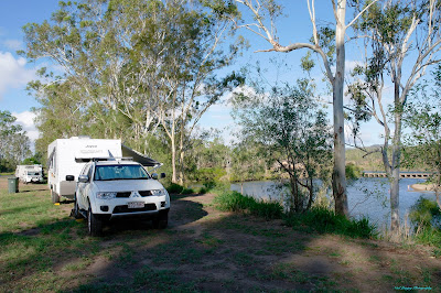
Gin Gin Rest Area
Another of our frequent stop-overs. Gin Gin is really close to home and is a great point for the first or last lay-over on our travels. Access to the town is via an easy walk of about 2 km. We arrived here after enduring a vast amount of road works for yet another day and we expect the same again tomorrow after we pull out of here.


Close to where we usually park, down the back away from the Bruce Highway. As usual quite a few campers in here as well.
Calliope Rest Area
Here we are again, camped on the high level side of the Calliope River. Really, we should try the low level side on at least one pass through the area. We had encountered quite a lot of road-works after leaving Rockhampton and appreciated the chance to pull off the road and camp for the night.


We usually find a good position close to the river bank with a great view along both reaches of the river. Lots of action on the other side this time with several families camped there for the school holidays.

Needed some exercise after driving for a couple of hours, went for a walk across the old condemned bridge that was the Old Bruce Highway to the low side of the river.
Tuesday, January 22, 2013
Yeppoon
This time through Rockhampton we turned off the Bruce Highway and stopped over in Yeppoon. We have some Hash House Harrier friends there, Kennell and MD. Otherwise known as Ken and Cheryl. We stayed at The Beachside Caravan Park, on The Byfield Road, for two nights and as the name suggests, it is beachside, we had sea views and woke with the sun coming up over The Keppell Islands.
We also had time to drive out to Byfield National Park and visit some of the sights there. We checked out Red Rock Camp Ground in the NP for possible caravan sites and found it suitable for the likes of our caravan. Red Rock Camp Ground is the only one in the Byfield NP suitable for caravans.
Yeppoon is expanding with new development happening at a great pace, but so far, has still retained it's "seaside charm".

Jude is studying the map of local sights while I am taking in the great vista that greats us from our awning.
St Lawrence Sports Ground
On our homeward travel we are going through territory and camps that we have been to on several occasions before. St Lawrence is one of those places. On a previous visit the weather was quite pleasant but this time the temperatures were blisteringly hot. The adjacent wetlands were almost totally dry. There are still considerable numbers of travellers on the road and St Lawrence is a popular stopover. There was also a Motorhome Club from Mackay visiting on their Monthly Meeting.
The town hasn't changed at all except that the Pub is now tourist friendly and was doing good business during the hot weather.
It was just too hot to get out and be the photographer so I have included this link to one of our previous visits, the buildings in the town are the same but the country side is totally different. http://avantouring.blogspot.com.au/2010/03/st-lawrence-3rd-to-5th-march.html
Thursday, January 17, 2013
Flaggy Rock
Homeward bound now, first stop over is Flaggy Rock. We are camped in behind the Community Centre there. The fee is only $5 per night and it is very quiet here. We are the only camp but in the busy season the 5 acres would be filled.


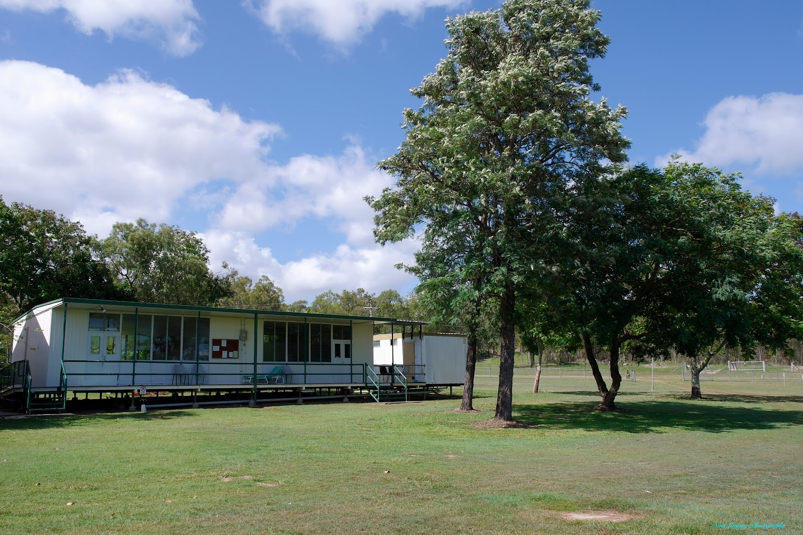
The rear of The Community Centre at Flaggy Rock. I suspect that this would have been a school building in years gone by.

There is 5 acres of grounds here and we are the only campers present along with the caretaker. Two large Mango Trees centre/left provide us with breakfast goodies.
Eungella
While staying with our good friends Ian and Sue in Mackay we went for a drive up to Eungella for the spectacular views down the Pioneer Valley back towards Mackay.


The Eungella Chalet has survived many cyclonic storms and is still functioning well today.

Looking up to the Dining Area of The Chalet over the swimming pool.

The launch platform for 'Hang Gliders'. Step off here and soar down The Pioneer Valley.

This is a great vista looking down along The Pioneer Valley. Any wonder Mackay has had serious flooding issues in the past.
Bundoora Dam
While travelling from Sapphire to Mackay we stopped over at the small Bundoora Dam. There are not many spots for caravan camping here but we managed the perfect location. There is a concrete pad remaining from some structure and we parked the van on that, perfect level, perfect view. A couple of campers down by the water's edge were doing alright netting Red Claw.


The dam wall is visible behind our caravan. The reservoir opens out much wider as the water extends out to the right.
Sapphire Caravan Park
While at Sapphire we stayed at The Sapphire Caravan Park. The park is situated at a most unusual location, at the top of a fairly steep hill but still easily accessed by large caravans. I do not usually make extensive comments about the caravan parks we visit but on this occasion we were made extremely welcome and the caravan park has a genuinely unique character that warranted this special report. The owners, Lee and Norm provide a very friendly atmosphere at this extensive caravan park. You can check out the full details of the Caravan Park at www.sapphirecaravanpark.com.au


Your welcome at the entry to Sapphire Caravan Park Retreat.

The booking Office and Main Residence.

Another Happy Fella outside the relaxing pool area.

The main drive past cabins and Camp Kitchen.

Outdoor Dining area at The Camp Kitchen.

I guess this is the smokers area outside the Camp Kitchen.

At one end of the Camp Kitchen there is an extensive library for guests.

The 'business end' of the well equipped Camp Kitchen.

Squeeze Box musician outside the BBQ Area.

Lots of tables and chairs in the BBQ Area that boasts overhead fans and TV for your comfort.

The Wallaby and bird feeding area as viewed from the BBQ Area.

An unusual visitor to camp.

Cabins and Huts aplenty at The Sapphire Caravan Park Retreat.

Our camp site provided plenty of space and was handy to all facilities.

Most caravan sites seem to be in individual locations and all are at different levels.

The view down the gully we had from our awning.
Sapphire and Rubyvale
We had stopped at the very neat and tidy town of Capella for lunch on the way through to Sapphire. We were actually stopped alongside the road that would take us directly to Rubyvale but our Garmin GPS would not recognise either of Sapphire or Rubyvale, these towns simply did not exist! We tried to be smart, difficult, I know, but we simply entered the co-ordinates for the free camp in Sapphire, surely that would get us there! We were presented with directions that would take us kilometres out of our way through the City of Emerald. We settled for using human grey matter and driving the shorter more direct route.
We hadn't been to Sapphire before and were keen to see what was there but the main purpose for heading that direction was Jim and Lee, people we had met at Apollo Bay in March 2012 were camped there and it seemed like a great opportunity to meet up again as we were passing through the same general area.
The towns of Sapphire and Rubyvale are unique in that most of the land cannot be owned freehold, but must be leased from a mining company. The leases are for a term of only 5 years, hence most of the residences are only constructed in a temporary manner. The up side is that there are no Council Rates, but also there are no services either.
To fossick for Gem Stones in the open fossicking areas a permit is required but this is relatively cheap considering the value of the stones that can be found. Be very careful not to enter on another person's lease though!

As most of the land is "Common Land" in both Rubyvale and Sapphire beef cattle are free to roam anywhere they desire and they have 'right-of-way' on the roads.

Between Rubyvale and Sapphire, a distance of only 8 km, you will see piles of rubble brought to the surface by the gem seekers.

Several of the miners have permits to use heavy machinery to seek their fortune. For most, a pick, a shovel and a bucket is all that is allowed. Only recently pneumatic jack hammers have been permitted.

One of the very few well established homes in the area.

The Pub at Rubyvale.

Jude and I had lunch at Tea Rooms at The Gem Gallery and this rather cheeky intruder tried to fly away with Jude's Toasted Sandwich.

One of the Tourist Attractions in Rubyvale, tour a working underground mine.

How mining was once performed, but back then there was only candle light.

Notice the regulation mining apparel. It was a quite cool 22 deg C underground while it was closer to 40 deg C up top.

One of the Gem Galleries in Sapphire.

Sapphire General Store and fuel.

Sapphire Hardware. All the businesses in Sapphire are spread over a wide area, you need to drive between each business.
Thursday, January 10, 2013
Belyando Crossing
At a point about half way between Charters Towers and Clermont on The Gregory Developmental Road, and the only reasonable place to stop for the night, is the Belyando Crossing Roadhouse and Caravan Park. At $15 for a site with no power and no water you can understand why we prefer to 'Free Camp' along the road. We were lucky to have another couple, Terry and June, stop over in the Caravan Park for the night and we had a long chat about each others travels.


Belyando River. There is no running water here on this occasion, only a couple of muddy puddles.
Charters Towers
We received a message about a possible Fraudulent Mastercard transaction on our Credit Card, we didn't have a satisfactory phone signal at the Campaspe River RA to resolve the issue so had to break camp early and head into Charters Towers to follow up with the credit provider. After driving into town wondering what was happening with our finances all the way in, we found that the transaction in question was not fraudulent at all but quite normal, from a respected company and for the princely sum of AU$4.76. I guess somebody had to prove their worth to the company. We spent the remainder of the day camped behind the BP Roadhouse reading The Courier Mail and waiting for the the next morning to travel south to Belyando Crossing in the cool of day.


This 'sort of' makes you feel insignificant doesn't it! A four trailer Freightliner Road Train parked beside our small combination.

Reading The Courier Mail was how we spent the afternoon.

Early morning at The Dump Point and filling our water tanks beside the rejuvenated Poppit Head from the last operating gold mine, that ceased operations in 2002.
Other photographs from an earlier visit :- http://avantouring.blogspot.com.au/2009/11/charters-towers-attractions-mon-9th-to.html
Sunday, January 6, 2013
Campaspe River Rest Area
Once more we get on the road very early to avoid the high temperatures and gusty easterlies.
Made Hughenden for morning tea, refuelled, had a look at the RV camping area for possible future stays. The RV area is in The Showgrounds and looks very good, with green grass and well maintained facilities. There is a fee involved though. Made camp at The Campaspe River RA, 90 kms west of Charters Towers on the Flinders Highway. We have stayed here before and on this occasion we were able to camp in the exact same location, behind a huge mango tree that blocked out most of the highway noise. However, the downside was the extra long freight trains thundering past only 35 metres away ---- not too many of those though. I only heard two trains during the night, one, I thought was coming through the van door!


Made Hughenden for morning tea, refuelled, had a look at the RV camping area for possible future stays. The RV area is in The Showgrounds and looks very good, with green grass and well maintained facilities. There is a fee involved though. Made camp at The Campaspe River RA, 90 kms west of Charters Towers on the Flinders Highway. We have stayed here before and on this occasion we were able to camp in the exact same location, behind a huge mango tree that blocked out most of the highway noise. However, the downside was the extra long freight trains thundering past only 35 metres away ---- not too many of those though. I only heard two trains during the night, one, I thought was coming through the van door!

Photograph taken early morning, from beside the rail line looking towards our camp and the Flinders Highway beyond.

The rail trestle over the Campaspe River. The river bed does not have any water, only truck loads of sand!
More photographs of the Campaspe River here on a previous post. http://avantouring.blogspot.com.au/2009/11/campaspe-river-rest-area-sat-7th-sun.html
Richmond RV Area
Up with the sun this morning at Julia Creek, planning an early departure to avoid the worst of the heat and the easterly winds as they pick up during the day.
Stopped at a roadside RA for morning tea and met a young couple from Richmond who had come out to clean the toilets and surrounds. Had a chat about important issues like road and weather conditions, types of vehicles for towing, brands of tyres to use and the tales of the influx of huge numbers of campers that arrive during the peak season of May through August.
The RV free camping area at Richmond consists of a gravelly paddock with no outlook what-so-ever but it does have a 'dump point' and is only one block north of the main street shopping area. An easy distance to walk in more normal temperatures.
It is too hot to get out with the camera on this visit. You can check back at this previous post for photos of Richmond.
http://avantouring.blogspot.com.au/2009/11/richmond-thurs-5th-and-fri-6th-nov.html
Friday, January 4, 2013
Julia Creek
After a fun stay with family in Mount Isa the time had come to say goodbye and leave this Outback City.
Have you heard of the statement 'According to Murphy's Law'? Well, it applied to us at this time. Having driven from Longreach to Cloncurry into W/NW 'head winds' on the way out to 'The Isa', we now face 'head winds' on the way out of 'The Isa'. From Cloncurry to Julia Creek we were punching E/NE winds gusting to 25 km/h. The wind was only one factor against us, the outside temperature was hovering between 43 C and 44 C as well.
I didn't like to push the car this hard, towing the van, so I slowed down our speed to relieve the stress on the vehicle. We were only 20 km from Julia Creek when the engine temp gauge shot up and the Auto Transmission Temp Warning Light came on, the first time I've ever seen it glowing it's red presence. We pulled off the highway and left the engine idling for about 8 minutes. All temperatures 'normalised' and we drove into our free camp 1.2 km east of Julia Creek. Very relieved to arrive without damage to us or the vehicle. The XXXX Bitter tasted wonderfully refreshing.

Julia Creek, a free camp and picnic area 1.2 km east of the Town of Julia Creek. Picnic tables and wood fired BBQ's aplenty. Nature Trail to walk, if you are inclined. We walked around to the other side of the creek and saw the 'slither' marks of a very large snake. We were very happy to not make acquaintances with it.

Our camp from a different aspect.

Jude resting in the shade of the van. Cattle flies were a bit of a nuisance, Jude donned a fly net but that makes drinking your XXXX Bitter too difficult.
Subscribe to:
Posts (Atom)