Saturday, March 31, 2012

Princetown, The Shipwreck Coast and Port Campbell

We settled in at The Princetown Recreation Ground and waited for the big blow that we knew was coming. All the powered sites were around the perimeter of the oval and open to the full force of the prevailing winds, we opted to nestle in under the protection of some bordering trees. Not having power meant we would be without heat, we got out all the blankets we had and managed to stay fairly warm. Even with the protection of the trees the van was rocking in the gale force gusts of wind. We didn't get to see much of Princetown, even though there is not much to see. Princetown does have a boardwalk through the nearby wetlands, that the residents are very proud of, but the weather was too inclement for us to follow the trail. I did not get the camera out of it's bag during the entire stay in the town. The only half decent day we experienced we took to the car and toured The Shipwreck Coast that begins only 6 km from Princetown.

The first viewpoint along the Shipwreck Coast is 'Gibson Steps'. This is the view from the top of the steps looking eastwards.

From the same vantage point at 'Gibson Steps' looking westward.

Gibson Steps are carved from the cliff face and take you down to the beach. Well worth the effort to get down there and back. The day was sunny in patches but still very windy. You needed to be well rugged up.

At the Twelve Apostles. These are two of the rock columns collectively know as The Twelve Apostles. We could only count 8 columns, the other 4 have been eroded away by the battering of the Southern Ocean.

This is what remains of the Twelve Apostles. I hope the photo is clear and sharp, it was extremely difficult to keep the camera steady in the wind.

We are now at 'Loch Ard Gorge'. At the entrance to this gorge is the place of the historic ship wreck of "The Loch Ard' that took so many lives. There were only two survivors to the tragedy.

This is the coastline looking eastwards from The Loch Ard Gorge.

Looking from the cliff top down to the very small beach area where the two survivors were fortunate enough to reach.

Another angle of the gorge entrance.

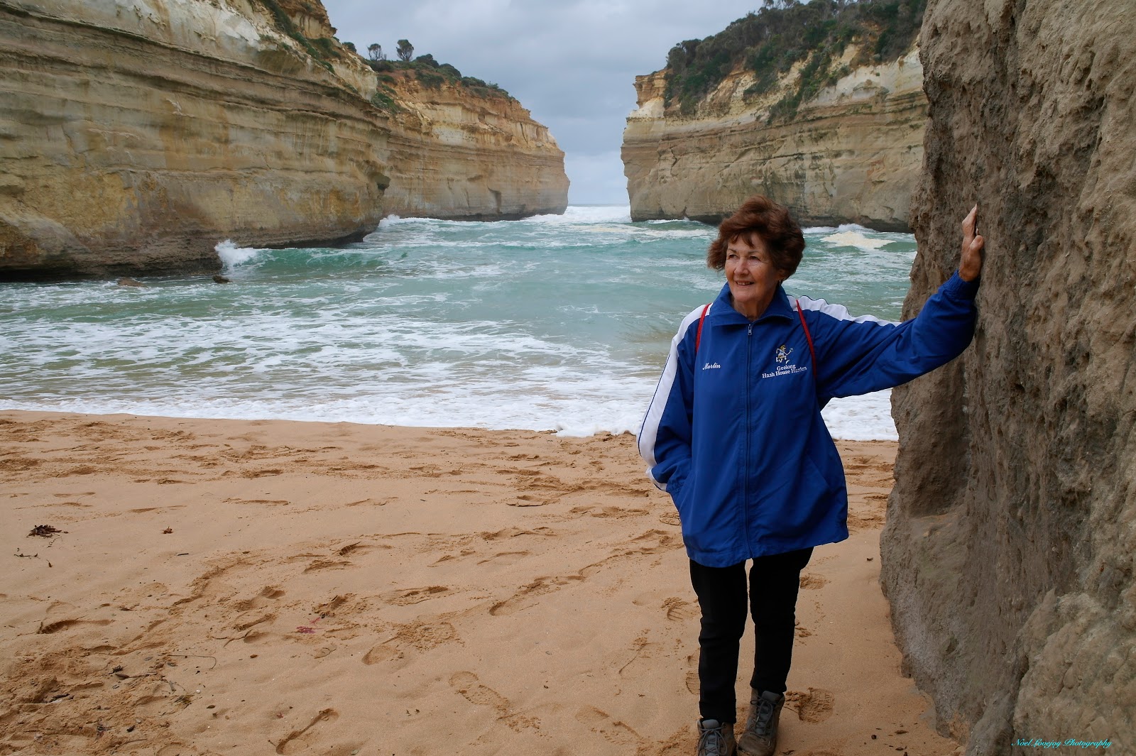
This is the view from the beach level looking out to the gorge entrance. There are signs aplenty, on the steps down to the beach, warning of the dangers in swimming in these waters.

The final Shipwreck Coast feature we visited was 'London Bridge'. This view is still very popular with travellers even though the main Arch collapsed around 1998 or so.

While touring The Shipwreck Coast we called into Port Campbell for lunch. This is the entrance into the port area. There is not a whole lot of protection from the open sea here.

A general view of the town precinct.

Looking back over the central picnic area towards the Surf Club.

Just through town on your travel towards the west, there is this lookout that provides a commanding view of the town of Port Campbell.

Wednesday, March 28, 2012

The Otway Fly

We chose an absolutely perfect day to visit the Otway Fly and surrounding areas. These days are few and far between in the Otways but today we have been blessed. The Otway Fly has a maximum height of 47 metres above the forest floor, this height almost places you in the tree canopies but not all the way! Just imagine, in the early days the loggers were taking out trees in excess of 500 metres tall.

From the entry kiosk there is a walk of about 300 metres to the beginning of the Otway Fly, along the way there is a section named The Dinosaur Trail. Situated in the bush along the trail are models of the dinosaurs that roamed the area at different intervals of the prehistoric past.

The range of ancient reptiles is amazing.

Really happy this one is not for real.

I really don't know how reptiles with wing spans this wide could fly through these forests.

This one seems docile, something Fred Flinstone would have as a pet.

Jude took a liking to this dangerous looking beast.

I was lucky to survive this encounter, it probably had already eaten!

Lee and Jim, visiting from Perth WA, on the end of the Canter Lever at the Otway Fly. 

A view of tree ferns from far above along the Otway Fly.

Back at ground level again, we noticed several fish in this stream, they looked a lot like trout, will bring a line next visit.

Following our visit to The Otway Fly we came back to Beach Forest for a picnic lunch at this park. This steel sculpture represents the height of Mountain Ash trees logged in the early days of the pristine forest. The tallest recorded tree was of 1823 feet (approx 556 metres), logged at Buchanan. That tree was probably in excess of 2000 years old at the time of logging.

Cape Otway

It was a cool and sometimes drizzly day but we decided to embark on a tour of parts of the Cape Otway National Park. In these areas if you wait for a perfect day you will miss on seeing anything if you only have a short visiting time.

We had followed a decline in the path into Elliott River and reached this small stream running through the forest. As you can see there are many ferns growing in the damp atmosphere of the forest.

The path arrives at a fork and one must make a decision! The left fork leads to Shelly Beach. This is a very small beach and is devoid of shells. I am puzzled as to the name for the beach? The sea was very quiet today but I can imagine waves pounding the sandy beach on wild days.

We back-tracked along the path from Shelly Beach and then followed the path option to the right. Along the way we caught this glimpse of the southern coast and Cape Otway through the trees.

Very close to the mouth of The Elliott River there is a small but pretty waterfall. There is a track that will take you to the falls.

This is the unspectacular entry to Bass Strait by The Elliott River. You can make it out through this pile of rubble.

About 10 km further along the Great Ocean Road you will arrive at the entry to 'Maits Rest'. This is a small reserve very close to the main road and it is only about 20 to 30 minutes to walk through. What this park lacks in distance it makes up for in being a great example of a temperate rainforest. You are walking through a forest of massive tree ferns. This photograph is of the beginning of the path, I didn't take my camera into the walk as it was very wet and there was a drizzle of rain.

We arrived at the Cape Otway Lighthouse only to discover that there is a substantial fee to enter the grounds to get a close-up view. A fee that we and many others were not going to pay. Hence, all you get is this far of photograph from a distant look-out point. The lighthouse sits on the most southerly point of the State of Victoria. We did hear later that if you tell a little white lie and state that you are from the town of Colac or some other nearby town you will be granted free entry. We never got to test that theory.

As you enter the Cape Otway National Park, there is a large colony of Koala. Some are photogenic, like this one, and struck a pose for the many cameras.

Another Koala wondering what I am doing at the base of his/her tree.

Saturday, March 24, 2012

Apollo Bay Agricultural Show

The home of the Annual Apollo Bay Agricultural Show is the Recreation Reserve. We and many others are camping in the large area of the Reserve, that meant that we had a frontline view and access to all the proceedings. We were very fortunate indeed to be able to take in all the events and the atmosphere of the Show.

One of the featured 'exhibits' at the show was the live creation a massive timber sculpture by the chainsaw artisan, Rob Blast from Seville, Victoria. Comments as to the eventual finished appearance ranged from Hammerhead Shark to Dolphin but not Whale. This is strange from people who live on the ocean coast with migrating whales passing close by.

This South American Macaw was also in attendance.

An overall photograph showing the colour and action of the Main Arena.

Beside the Main Arena, squeezed in to every corner were supplementary activities such as sheep handling with dogs and childrens' high slide.

This young female Koala was lapping up all the attention from many children wanting to pat her.

The delicate finishing touches to the Whale.

The finished article. The whole project took about 8 hours to complete. The piece was later auctioned and fetched a price of $800.00

The final event at the Show was the canine fence jump. This Whippet was the 'Runner-Up' contestant, seen here scaling a height of around 2.35 metres.

The winner of the canine fence jump was this keen contestant, seen here scaling the height of 2.4 metres, the only contestant to achieve that feat.

Friday, March 23, 2012

Apollo Bay Foreshore

Apollo Bay was always one of our favourite destinations during the time we lived in Geelong. This town was always going to be a "must do" destination for us. We camped in the Recreation Reserve and met so many wonderful travellers during our stay.

Went on our maiden cycle ride with our fold up bikes from Aldi. They have experienced some inclement weather here at Apollo Bay and some of the foreshore cycle/walk path has been destroyed, like this section here.

The view across the foreshore towards the town area and the marina.

On our cycle ride we came across these guys playing a game with one rubber thong. The idea is, there is an inner circle drawn in the sand, one person is in the centre with the thong, the others are on the circle, the centre person tosses the thong into the air and the others gain as much distance as they can before the thong lands on the sand, the centre person then attempts to contact one of the others with the thong, if successful, that person then takes the centre position and the game goes on.

The tide is out at this time and we are closer to the town.

This is the Tourist Information Centre. It is situated on the foreshore reserve at the east end of the CBD.

On the foreshore reserve there are many pieces of wooden sculpture, including these great seal pieces.

There are also 'totem' like sculpture pieces.

This is the beginning of the CBD approaching from the eastern end of town.

There are other inclusions along the foreshore park, like this relic from the sailing ship days. That's the ship's anchor I'm talking about, not Judy.

This view from Marengo, a satellite suburb of Apollo Bay, looking eastwards towards Apollo Bay. Notice the rolling hills behind the town.

Another angle from Marengo taking in Seal Rocks and the paddle boarders in the middle ground.

This fantastic view is from Marriner's Lookout at Apollo Bay, looking eastwards towards Skene's Creek. Unfortunately crews were burning-off in the valleys beyond Skene's Creek and the smoke-haze has obliterated the extended view.


From Marriner's Lookout looking westwards towards Apollo Bay and Marengo, you would almost think that you are flying in an aircraft the lookout is that high.