Showing posts with label Southern Ocean. Show all posts

Friday, May 11, 2012

Strathalbyn and Goolwa

Our plan was to use Strathalbyn as a base point to restock the pantry and to refresh the water and fuel supply. At the same time we were going to make a side trip to Goolwa to see Hindmarsh Island, The Coorong and the place where the Murray River waters exit Lake Alexandrina into the Southern Ocean. There is not always a flow of water through this point but following good flows from the Darling and Murrumbidgee Rivers as well as the Murray River itself water levels are at points not seen for several years. Strathalbyn is a very picturesque town in the Fleurieu Penninsula Wine Region of South Australia.

Travelling to Strathalbyn we stayed a night at this free camp situated beside the Nurrung Ferry. There were twenty people staying this night, including one traveller from Germany and two from Austria.

Our caravan is behind this small shelter. All of the campers gathered in the shelter for 'Happy Hour', this resulted in a raucous babble of voices each passing on important travel details.

The Nurrung Ferry crosses the Narrows, a strip of water linking Lakes Alexandrina and Albert. All the Ferries that cross the Murray are free and run 24 hours a day.

Strathalbyn branch of the Bank of SA, an imposing building in the main street.

The Laucke Milling Co. This building is still used to produce the bread making flour that we buy in Hervey Bay.

From one of the highest points in town this magnificent church looks over Central Park, Strathalbyn.

One view of the extensive Central Park in Strathalbyn. As the name implies, the park that borders the Angas River is really the central point of the town.

This photograph is typical of the look of Strathalbyn's Central Business Area.

Lake Alexandrina and the opening to the Southern Ocean, the point where the excess water from the Darling, Murrumbidgee, Murray and many other Rivers flows. This photograph taken from Hindmarsh Island.

A view of the Hindmarsh Island Bridge from the Goolwa Wharf area.

Looking under the Hindmarsh Bridge to the western reach of Lake Alexandrina.

A view of the Goolwa Wharf Precinct from the top of the Hindmarsh Island Bridge.

It was a Sunday when we visited Goolwa and there was an excellent market, it was very well attended by both patrons and stall holders.

On our return journey to Strathalbyn we took a detour to Milang, a small town on the shores of Lake Alexandrina. Another long jetty.

The foreshore park at Milang and the caravan park to the left. This would be a great area to camp in better weather and if you were into fishing.

Wednesday, April 11, 2012

Cape Nelson and Cape Bridgewater

Access to the "two capes" is through Portland. Cape Nelson is a rocky windswept outcrop jutting into the Southern Ocean with a lighthouse erected on the point. There is nothing else to say of it. Cape Bridgewater, on the other hand, is also a windswept rocky outcrop, with only two forms of vegetation being able to exist there, but there is also a very beautiful beach on a sweeping coastline to the east of the cape.

The lighthouse at Cape Nelson. You will notice scaffolding around the light due to maintenance operations. The result was that this is as close as to the lighthouse as any tourist could hope to get.

The ever present Southern Ocean swells crash into the rocks at Cape Nelson and cascade into the air.

Very similar to the previous photograph, same effect different location. This is Cape Bridgewater,

Also at Cape Bridgewater is a formation known as 'The Petrified Forest'. The rock casings that formed around tree trunks millennia ago are very evident.

With the sparse vegetation of Cape Bridgewater in the foreground, beyond the car park you can detect one of the reasons your electricity bill is getting larger by the quarter. This is only a small section of the "subsidised and uneconomic wind farms" that are all over the western Victorian coast. On this day the blades were basically stationary.

The very beautiful beach at Bridgewater with the Cape in the background.

Saturday, March 31, 2012

Princetown, The Shipwreck Coast and Port Campbell

We settled in at The Princetown Recreation Ground and waited for the big blow that we knew was coming. All the powered sites were around the perimeter of the oval and open to the full force of the prevailing winds, we opted to nestle in under the protection of some bordering trees. Not having power meant we would be without heat, we got out all the blankets we had and managed to stay fairly warm. Even with the protection of the trees the van was rocking in the gale force gusts of wind. We didn't get to see much of Princetown, even though there is not much to see. Princetown does have a boardwalk through the nearby wetlands, that the residents are very proud of, but the weather was too inclement for us to follow the trail. I did not get the camera out of it's bag during the entire stay in the town. The only half decent day we experienced we took to the car and toured The Shipwreck Coast that begins only 6 km from Princetown.

The first viewpoint along the Shipwreck Coast is 'Gibson Steps'. This is the view from the top of the steps looking eastwards.

From the same vantage point at 'Gibson Steps' looking westward.

Gibson Steps are carved from the cliff face and take you down to the beach. Well worth the effort to get down there and back. The day was sunny in patches but still very windy. You needed to be well rugged up.

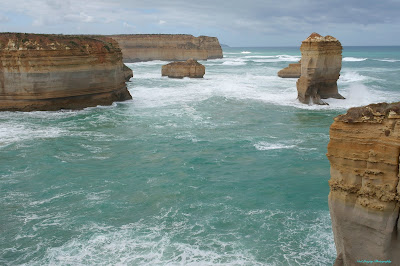
At the Twelve Apostles. These are two of the rock columns collectively know as The Twelve Apostles. We could only count 8 columns, the other 4 have been eroded away by the battering of the Southern Ocean.

This is what remains of the Twelve Apostles. I hope the photo is clear and sharp, it was extremely difficult to keep the camera steady in the wind.

We are now at 'Loch Ard Gorge'. At the entrance to this gorge is the place of the historic ship wreck of "The Loch Ard' that took so many lives. There were only two survivors to the tragedy.

This is the coastline looking eastwards from The Loch Ard Gorge.

Looking from the cliff top down to the very small beach area where the two survivors were fortunate enough to reach.

Another angle of the gorge entrance.

This is the view from the beach level looking out to the gorge entrance. There are signs aplenty, on the steps down to the beach, warning of the dangers in swimming in these waters.

The final Shipwreck Coast feature we visited was 'London Bridge'. This view is still very popular with travellers even though the main Arch collapsed around 1998 or so.

While touring The Shipwreck Coast we called into Port Campbell for lunch. This is the entrance into the port area. There is not a whole lot of protection from the open sea here.

A general view of the town precinct.

Looking back over the central picnic area towards the Surf Club.

Just through town on your travel towards the west, there is this lookout that provides a commanding view of the town of Port Campbell.