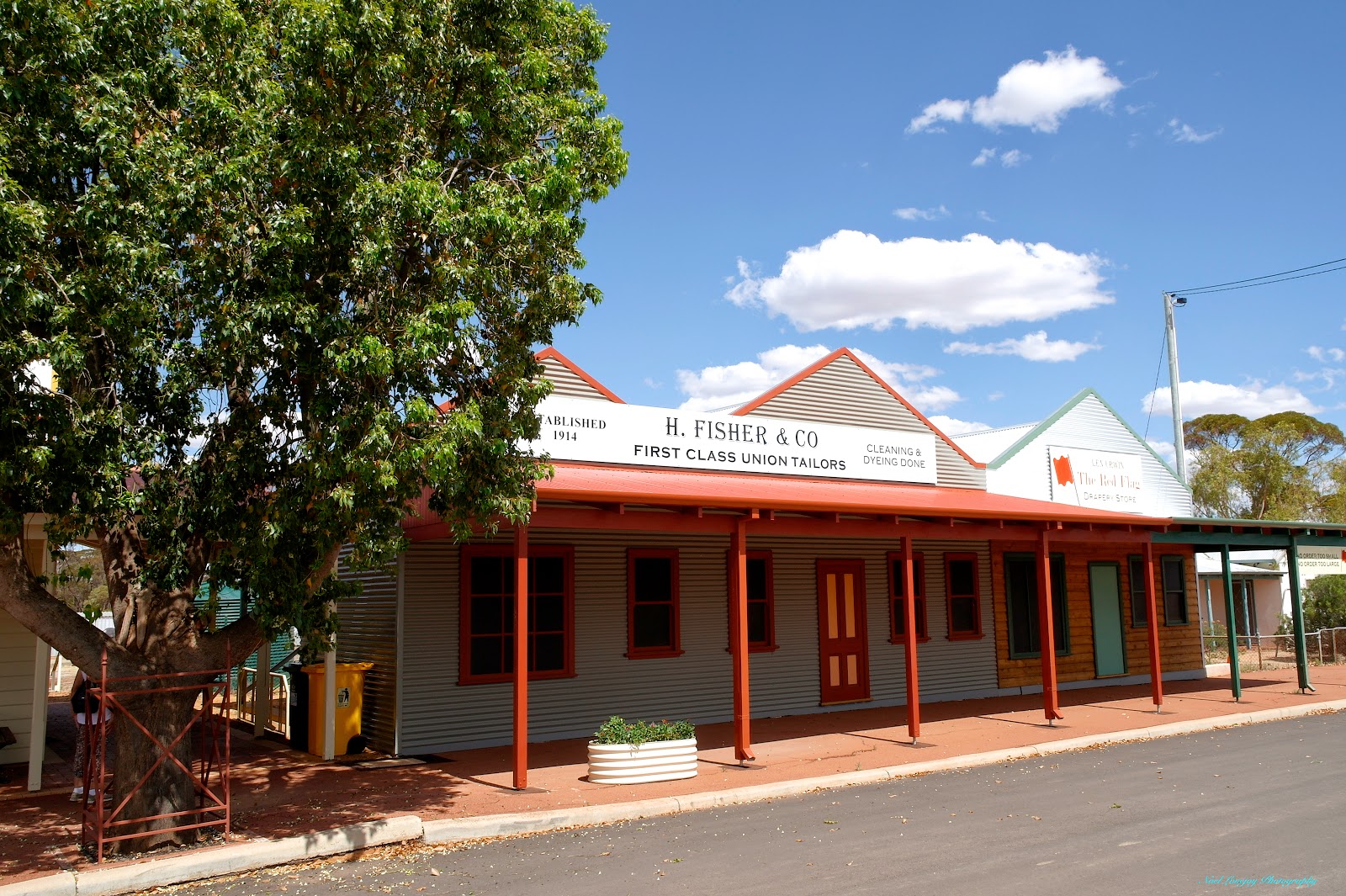
We diverted from our route to visit the quaint town of Westonia, where things are not what they initially seem to be. The Main Street buildings are constructed with modern materials but are made to imitate the original old buildings. Westonia is surrounded by cropping country but is also host to Edna May Gold Mine, the mine workings can be heard as you walk the very quiet Main Street.
Another diversion we made was to Karalee Rock and Dam. This Dam was constructed about 1900 to provide water for the Steam Locomotives on the newly opened Railway. The dam collects the rain run-off from a vast slab of granite in a very ingenious manner.
Since we left Bundaberg in early September we have wound on another 10,000 km to the Odometer, time for the next service and we have the BT50 booked into Kalgoorlie Mazda for that. As we have covered that territory previously we will not be publishing another blog post until we cover some new and interesting sights.

No guessing where we are now. The large banner on this implement tells it all.

This is a "Farm Made" tractor assembled out of a collection of parts. It was used continuously for many years.

The Information Centre is located in a shady position.

The old Mukinbudin Railway Station.

Memorial Hall.

Another of the well maintained buildings in the Main Street.

These Salmon Gums in the Caravan Park come in many colours, all at the same time.

The entrance to Westonia gives you a sense of what is to come.

The buildings are all newly constructed to represent the old town but what happens behind the facade is something else.

Behind the facades you will find all the services you would find in a similar sized town.

I think the Shire Offices were behind this facade.
This was one exception to the rule though.

This is only car parking space.

The Club Hotel is really a Museum of the original Hotel. Complete with fake Bar and Staff. Unfortunately it wasn't open during our visit.

Gold is part of the history of the town.

The old battery sits idle now days.

The town is very well presented and is a credit to the people of the Shire.

A private home gets in on the fun of the town as well with this Pink Elephant created out of a hand operated concrete mixer.

Karalee Rock, is a vast slab of granite that extends for about another kilometre behind where I am standing.

When there is a rain event all the run-off from the rock is diverted by the rock walls that circle the granite slab into this sluice channel.

The water flow then travels through this regulator gate.

The water flow then passes along this Riveted Steel Aquaduct that is supported by timber trusses.

The water then flows into the Dam where it was later pumped to the nearby rail line. The dam holds over 18,000,000 litres. As the water is collected on rock the contents of the dam is very clear.

Although the water was mainly harvested for the railway locomotives the authorities were realistic enough to make it available to the general population from this self filling well at two shillings and six pence per 100 gallons or 25 cents per 450 litres.
No comments:
Post a Comment